Town takes steps to prepare for future I-40 interchange
With major changes slated in the coming years for Blue Ridge Road, between the I-40 overpass and N.C. 9, residents had the opportunity to provide input on the future of the area.
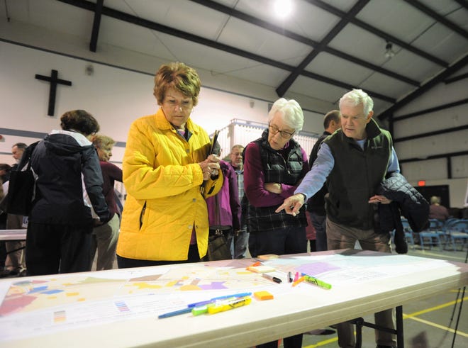
The first steps in developing a small area plan were taken on March 14, at Meadowbrook Baptist Church, where over 30 people showed up for a meeting with those involved in the project.
The town of Black Mountain hosted the meeting, which was facilitated by director of planning and development Jessica Trotman and featured a presentation from Drew Draper of Wetherill Engineering and Richard Smith of McGill Associates.
“I’d like to preface this with letting you all know that this is really an opportunity to tell us what you want to see on Blue Ridge Road,” Trotman said at the outset of the meeting. “That can be things that are already there now or things that aren’t there now, whatever your ideas are. My job is to help make sure those things become reality.”
Wetherill Engineering is serving as the project lead on the development of a small area plan, Draper said.
“While our firm is leading the effort overall, we’re going to focus on the transportation and land use side of things, because this is a transportation and land use study,” he said. “We have McGill Associates on as our subject experts for the land use side of things.”

Draper described the project as a long-range plan that would typically unfold over 10-20 years.
“The reason this area was selected is, I’m sure most of you are aware, you have this new interchange project coming in,” he said. “With any sort of a change like that there will be a change in conditions, so you want to start thinking about what that means for the community and prepare for it.”
The small area plan will “guide future land use decisions,” he continued.
“The plan itself is not a decision, it’s to take your input on what you want to see,” Draper said. “Then it can be a tool used by the town and the board to make decisions.”
The plan, a $30,000 budgeted expense, will be turned over to the town in the summer. While not part of the interchange project, the small area plan is intended to allow the town to prepare for its impact on the surrounding area.
“A do-nothing scenario could be a bad scenario,” Draper said. “Because you could have unwanted development come in that might not fit within the context of what you want to do.”
Draper listed several municipalities, including Greenville, Apex and Raleigh, that have developed similar plans.
“There is one in Huntersville, just north of Charlotte; it’s a small town,” he said showing a slide of a strip of land. “I like this example because it’s similar to what we’re looking at here on Blue Ridge Road. It’s a small community with a small two-lane road that cuts right through.”
The plan utilized there, Draper said, allows for mixed-use, single family homes, multimodal transportation, trails and other options in a similar community.
Smith acknowledged that the area “probably wouldn’t stay the same” with the arrival of the interchange, but added that Blue Ridge Road would remain two lanes.
“What you want to do is influence that change,” he said.
The transportation aspect of the plan creates an opportunity to explore potential traffic calming measures, Draper said.
“That will be very important because we’ll have to think about aligning our transportation concepts and ideas with the adjacent land use,” he said.
The interchange should reduce the amount of tractor-trailer traffic on the road itself, Draper said.
"We'll have an increase in overall traffic on Blue Ridge Road, that's the nature of these projects," he said.
An integrated land use and transportation plan, he continued, allows the town to consider transportation options that complement the types of developments that could eventually come to the area.
"You can align multimodal opportunities with that," Draper said. "What it means is you look at bike lanes, sidewalks, trails, nice pedestrian crossings to interconnect. You start thinking about those things now so you can avoid development sprawl where you have isolated communities that aren't at all connected."
Following the presentation, attendees were given green stickers to be used to select features and characteristics they would like to see included in the plan. The vast majority of them prioritized sidewalks and multiuse paths as transportation options that should be included.
After the meeting, the next step in the process, according to Draper, is to gather the feedback.
"We'll digest it, think a little bit on it and do our transportation and land use assessment," he said. "We'll put forth a draft plan and come back and share that."

Three nights before the small area plan input meeting, Black Mountain elected officials received an update on the interchange from NCDOT project development engineer for Division 13, Steve Cannon.
Cannon was among the state department's representatives who attended a meeting unveiling three preliminary designs, last December.
"We had 33 written comments supplied after that meeting," he said. "Of those, 42 percent favored Alternate 2."
All of the alternates contain plans for a new bridge on Blue Ridge Road, north of I-40, over the Swannanoa River and a third lane for that stretch of road as well.
Alternate 2 features roundabouts north and south of the overpass.
"These are full movement roundabouts," Cannon said.
Alderman Carlos Showers asked Cannon how many homes would be impacted by the interchange.
"About seven," he responded. "That was the benefit of a roundabout design, because it has less impact that what was previously presented several years ago."
Aldermen voted unanimously to support the Alternate 2 design.
The interchange plan is among the items in the 2020-2029 draft State Transportation Improvement Plan (STIP) that will be voted on by the board of transportation in the summer.
"In that draft STIP this project has been pushed out one fiscal year to 2022," Cannon said. "Many of our projects throughout the state were pushed out due to increased construction costs, but keep in mind it doesn't mean it will be pushed out a full 12 months."
The NCDOT will determine which alternate will be used for the project within the next month, Cannon said, before handing it over to the design team for the final design.
"We will get to right-of-way (acquisition) stage later this year," he said.